| Kingston-upon-Thames | |
|---|---|
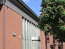
 Kingston upon Thames Guildhall | |
| Area | |
| • 1911 | 1,133 acres (4.6 km2) |
| • 1931 | 1,131 acres (4.6 km2) |
| • 1961 | 1,408 acres (5.7 km2) |
| Population | |
| • 1911 | 37,975 |
| • 1931 | 39,055 |
| • 1961 | 36,461 |
| Density | |
| • 1911 | 33/acre |
| • 1931 | 34/acre |
| • 1961 | 26/acre |
| History | |
| • Origin | Kingston-upon-Thames ancient borough |
| • Created | 1835 |
| • Abolished | 1965 |
| • Succeeded by | London Borough of Kingston upon Thames |
| Status | Municipal borough (1835—1965) Royal borough (confirmed 1927) Civil parish (1894—1965) |
| Government | Kingston Corporation |
| • HQ | Market House (1840–1935) Guildhall (1935–1965) |
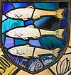
 Stained-glass emblazonment of Coat of Arms | |
Kingston-upon-Thames (spelt with hyphens) was a local government district in north east Surrey, England from 1835 to 1965 around the town now known as Kingston upon Thames. It was alternatively known as Kingston on Thames (spelt with or without hyphens).[1][2] It was a municipal borough and also held the rarer status of Royal borough. The district was abolished in 1965 and was replaced with the larger London Borough of Kingston upon Thames in Greater London, with the Royal borough status passed to the new district.

- ^ Great Britain Historical GIS / University of Portsmouth, Kingston upon Thames MB (historic map). Retrieved 2009-10-29.
- ^ On the question of hyphenation, see official documents and other publications from before 1 April 1965.
© MMXXIII Rich X Search. We shall prevail. All rights reserved. Rich X Search
